Yamanote Line
|
Yamanote Line
山手線 |
|||
|---|---|---|---|
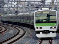 E231-500 series EMU headed for Tokyo and Shinagawa |
|||
| Overview | |||
| Type | Heavy rail | ||
| Locale | Tokyo | ||
| Termini | Shinagawa (loop) | ||
| Stations | 29 | ||
| Daily ridership | 3,232,190 (daily, 2008)[1] | ||
| Operation | |||
| Opened | 1885 | ||
| Operator(s) | JR East | ||
| Rolling stock | E231-500 series | ||
| Technical | |||
| Line length | 34.5 km (21.44 mi) | ||
| Track gauge | 1,067 mm (3 ft 6 in) | ||
| Electrification | 1,500 V DC overhead catenary | ||
| Operating speed | 90 km/h (56 mph) | ||
|
|||
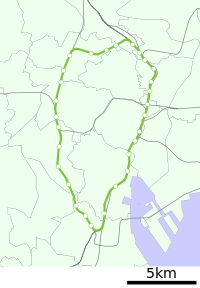
The Yamanote Line (山手線 Yamanote-sen) of East Japan Railway Company (JR East) is one of Tokyo's busiest and most important commuter rail lines. Running as a loop line, it connects most of Tokyo's major stations and urban centres including the Yūrakuchō/Ginza area, Shibuya, Shinjuku, and Ikebukuro with all but two of its 29 stations connecting to other railway or underground (subway) lines.
The "Yamanote Line" as an official line name indicates the tracks between Shinagawa and Tabata that is used by local trains on their own tracks as well as the parallel Yamanote Freight Line which is used by Saikyō Line and Shōnan-Shinjuku Line trains, some limited express services, and freight trains. However, in everyday usage the "Yamanote Line" refers to the entire 34.5 km loop line served by local trains. (This article uses the same definition.)
Contents |
Service
Trains run from 04:26 to 01:18 the next day at intervals as short as 2.5 minutes during peak periods and four minutes at other times. A complete loop takes 61 to 65 minutes. All trains stop at each station. Trains are put into and taken out of service at Ōsaki (which for timetabling purposes is the line's start and terminus) and sometimes Ikebukuro and Shinagawa. In the mornings, certain counter-clockwise trains start from Tamachi (which is more efficient, being located close to the Yamanote Line depot near Ōimachi). Trains which run clockwise are known as sotomawari (外回り) “outer circle“ and those counter-clockwise as uchi-mawari (内回り) “inner circle”. (Trains travel on the left in Japan, as with road traffic.)
The line also acts as a fare zone destination for JR tickets from locations outside Tokyo, permitting travel to any JR station on or within the loop. This refers to stations on the Yamanote Line as well as the Chūō-Sōbu Line between Sendagaya and Ochanomizu.
The line colour used on all rolling stock, station signs and diagrams is JNR Yellow Green #6 (■, Munsell code 7.5GY 6.5/7.8), known in Japanese as "Japanese Bush Warbler green" (ウグイス色 uguisu-iro).
History
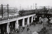
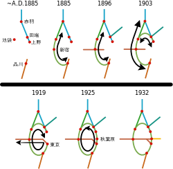
The Yamanote Line originated in 1885 with the construction of the Shinagawa Line (品川線 -sen) between Shinagawa and Akabane, bypassing the then built up areas and providing the first north-south rail link through Tokyo. The top part of the loop between Ikebukuro and Tabata was completed in 1903 (known as the Toshima Line (豊島線 -sen)) and following electrification in 1909 both lines were merged to become the Yamanote Line. The loop was not complete at this time, so trains generally inter-operated with the Chūō and Keihin-Tōhoku lines, traveling from Nakano to Tokyo Station, south to Shinagawa, then clockwise around the Yamanote Line to Tabata.
The loop was completed in 1925 with the opening of the section of track between Kanda and Ueno, providing a north-south link via Tokyo Station through the city's business centre. A parallel freight line, also completed in 1925, ran along the inner side of the loop between Shinagawa and Tabata.
During the prewar era, the Ministry of Railways did not issue permits to private suburban railway companies for new lines to cross the Yamanote from their terminal stations to the central districts of Tokyo, forcing to terminate services at stations on the line. This policy led to the development of new urban centers (新都心、副都心 shintoshin, fukutoshin) around major transfer points on the Yamanote Line, most notably at Shinjuku and Ikebukuro (which are now the two busiest passenger railway stations in the world).
The contemporary Yamanote Line came into being in 1956 when it was separated from the Keihin-Tōhoku Line and given its own set of tracks along the eastern side of the loop between Shinagawa and Tabata. However, Yamanote Line trains continued to periodically use the Keihin-Tōhoku tracks, particularly on holidays and during off-peak hours, until rapid service trains were introduced on the Keihin-Tōhoku Line in 1988.
A major explosion on the Yamanote Freight Line in Shinjuku in 1967 led to the diversion of freight traffic to the more distant Musashino Line. To address severe undercapacity, the freight line was repurposed for use by Saikyō Line and Shōnan-Shinjuku Line trains, as well as certain limited express trains such as the Narita Express and some liner services. Likewise, there are currently plans to extend the Tōhoku Main Line to Tokyo Station to provide further relief on the busiest portion of the Yamanote Line today, the southbound segment between Ueno and Okachimachi.
The distance between Shinagawa and Tamachi stations is 2.2 km, making it the longest stretch of track on the Yamanote Line. As a result, there are plans for a new station between those two stations.
Ridership
An estimated 3.5 million passengers ride every day on Tokyo's Yamanote Line, with its 29 stations. For comparison, the New York City Subway carries 5.08 million passengers per day on 26 lines serving 468 stations[2] and the London Underground carries 2.7 million passengers per day on 12 lines serving 275 stations[3]
Name
"Yamanote" literally refers to inland, hillier districts or foothills (as distinct from areas close to the sea). In Tokyo "Yamanote" lies along the western side of the Yamanote Line loop. The word consists of the Japanese morphemes yama 'mountain', no genitive suffix, and te 'hand', thus "mountain's hand".
Yamanote-sen is officially written in Japanese without the kana no (の、ノ), which makes its pronunciation ambiguous in print. The characters 山手 may also be pronounced yamate, as in Yamate-dōri (Yamate Street) which runs parallel to the west side of the Yamanote Line. The Seishin-Yamate Line in Kobe and the Yamate area of Yokohama also use this pronunciation.
After World War II, SCAP ordered all train placards to be romanized, and the Yamanote Line was romanized as "YAMATE LINE." It was thus alternatively known as "Yamanote" and "Yamate" until 1971, when the Japanese National Railways changed the pronunciation back to "Yamanote." Some older people still refer to the line as the "Yamate Line."
In 1971, JNR changed all train line signage to specify the pronunciation of line names. This change is attributed to the opening of the Agatsuma Line, which could be incorrectly pronounced "Azuma" as the kana ga (が、ガ) is omitted in its written name. As part of this change, JNR decided to adopt the Yamanote pronunciation, one reason being that there is a Yamate Station on the Negishi Line in nearby Yokohama.
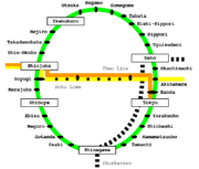
Station list
- Stations are listed in order clockwise from Shinagawa to Tabata, but for operational purposes trains officially start and terminate at Ōsaki.
- "Clockwise" (外回り sotomawari): Shinagawa → Shinjuku → Ikebukuro → Tabata → Ueno → Tokyo → Shinagawa
- "Counter-clockwise" (内回り uchimawari): Shinagawa → Tokyo → Ueno → Tabata → Ikebukuro → Shinjuku → Shinagawa
- All stations are located in the special wards of Tokyo.
- All trains on the Yamanote Line are local trains that stop at all stations.
- The "(R)" mark denotes stations where cross-platform transfers to Keihin-Tōhoku Line rapid services are possible.
| Line Name | Station | Japanese | Distance (km) | Transfers | Location | |
|---|---|---|---|---|---|---|
| Between Stations |
Total | |||||
| Yamanote Line |
Shinagawa | 品川 | from Tamachi 2.2 |
0.0 | East Japan Railway Company (JR East): Keihin-Tōhoku Line, Tōkaidō Main Line, Yokosuka Line Central Japan Railway Company (JR Central): Tōkaidō Shinkansen Keihin Electric Express Railway (Keikyū): Main Line |
Minato |
| Ōsaki | 大崎 | 2.0 | 2.0 | JR East: Shōnan-Shinjuku Line, Saikyō Line Tokyo Waterfront Area Rapid Transit: Rinkai Line |
Shinagawa | |
| Gotanda | 五反田 | 0.9 | 2.9 | Tokyu Corporation: Ikegami Line Toei: Asakusa Line (A-05) |
||
| Meguro | 目黒 | 1.2 | 4.1 | Tōkyū: Meguro Line Tokyo Metro: Namboku Line (N-01) Toei: Mita Line (I-01) |
||
| Ebisu | 恵比寿 | 1.5 | 5.6 | JR East: Shōnan-Shinjuku Line, Saikyō Line Tokyo Metro: Hibiya Line (H-02) |
Shibuya | |
| Shibuya | 渋谷 | 1.6 | 7.2 | JR East: Shōnan-Shinjuku Line, Saikyō Line Keio Corporation: Inokashira Line Tōkyū: Den-en-toshi Line, Tōyoko Line Tokyo Metro: Ginza Line (G-01), Hanzōmon Line (N-01), Fukutoshin Line (F-16) |
||
| Harajuku | 原宿 | 1.2 | 8.4 | Tokyo Metro: Chiyoda Line (Meiji-Jingūmae: C-03) | ||
| Yoyogi | 代々木 | 1.5 | 9.9 | JR East: Chūō-Sōbu Line Toei: Ōedo Line (E-26) |
||
| Shinjuku | 新宿 | 0.7 | 10.6 | JR East: Chūō Main Line, Chūō Line (Rapid), Chūō-Sōbu Line, Shōnan-Shinjuku Line, Saikyō Line Keiō: Keiō Line, Keio New Line Odakyu Electric Railway: Odawara Line Seibu Railway: Shinjuku Line (Seibu-Shinjuku) Tokyo Metro: Marunouchi Line (M-08) Toei: Shinjuku Line (S-01), Ōedo Line (E-27, Shinjuku-Nishiguchi: E-01) |
Shinjuku | |
| Shin-Ōkubo | 新大久保 | 1.3 | 11.9 | |||
| Takadanobaba | 高田馬場 | 1.4 | 13.3 | Seibu: Shinjuku Line Tokyo Metro: Tōzai Line (T-03) |
||
| Mejiro | 目白 | 0.9 | 14.2 | Toshima | ||
| Ikebukuro | 池袋 | 1.2 | 15.4 | JR East: Saikyō Line, Shōnan-Shinjuku Line Seibu: Ikebukuro Line Tōbu Railway: Tōjō Line Tokyo Metro: Marunouchi Line (M-25), Yūrakuchō Line (Y-09), Fukutoshin Line (F-09) |
||
| Ōtsuka | 大塚 | 1.8 | 17.2 | Toei: Toden Arakawa Line (Ōtsuka-Ekimae) | ||
| Sugamo | 巣鴨 | 1.1 | 18.3 | Toei: Mita Line (I-15) | ||
| Komagome | 駒込 | 0.7 | 19.0 | Tokyo Metro: Namboku Line (N-14) | ||
| Tabata | 田端 | 1.6 | 20.6 | JR East: Keihin-Tōhoku Line (R) | Kita | |
| Tōhoku Main Line |
||||||
| Nishi-Nippori | 西日暮里 | 0.8 | 21.4 | JR East: Keihin-Tōhoku Line Tokyo Metro: Chiyoda Line (C-16) Toei: Nippori-Toneri Liner (02) |
Arakawa | |
| Nippori | 日暮里 | 0.5 | 21.9 | JR East: Jōban Line, Keihin-Tōhoku Line Keisei Electric Railway: Main Line Toei: Nippori-Toneri Liner (01) |
||
| Uguisudani | 鶯谷 | 1.1 | 23.0 | JR East: Keihin-Tōhoku Line | Taitō | |
| Ueno | 上野 | 1.1 | 24.1 | JR East: Tōhoku Shinkansen, Jōetsu Shinkansen, Yamagata Shinkansen, Akita Shinkansen, Nagano Shinkansen, Jōban Line, Keihin-Tōhoku Line (R), Utsunomiya Line (Tōhoku Main Line), Takasaki Line Keisei: Main Line (Keisei Ueno) Tokyo Metro: Ginza Line (G-16), Hibiya Line (H-17) |
||
| Okachimachi | 御徒町 | 0.6 | 24.7 | JR East: Keihin-Tōhoku Line | ||
| Akihabara | 秋葉原 | 1.0 | 25.7 | JR East: Chūō-Sōbu Line, Keihin-Tōhoku Line (R) Metropolitan Intercity Railway Company: Tsukuba Express (01) Tokyo Metro: Hibiya Line (H-15) |
Chiyoda | |
| Kanda | 神田 | 0.7 | 26.4 | JR East: Chūō Line (Rapid), Keihin-Tōhoku Line Tokyo Metro: Ginza Line (G-13) |
||
| Tokyo | 東京 | 1.3 | 27.7 | JR East: Tōhoku Shinkansen, Jōetsu Shinkansen, Yamagata Shinkansen, Akita Shinkansen, Nagano Shinkansen, Keihin-Tōhoku Line (R), Tōkaidō Line, Chūō Line (Rapid), Yokosuka Line, Keiyō Line, Sōbu Line (Rapid) JR Central: Tōkaidō Shinkansen Tokyo Metro: Marunouchi Line (M-17) |
||
| Tōkaidō Main Line |
||||||
| Yūrakuchō | 有楽町 | 0.8 | 28.5 | JR East: Keihin-Tōhoku Line Tokyo Metro: Yūrakuchō Line (Y-18), Hibiya Line (Hibiya: H-07), Chiyoda Line (Hibiya: C-09) Toei: Mita Line (Hibiya: C-09) |
||
| Shimbashi | 新橋 | 1.1 | 29.6 | JR East: Tōkaidō Main Line, Yokosuka Line, Keihin-Tōhoku Line Tokyo Metro: Ginza Line (G-08) Toei: Asakusa Line (A-10) Tokyo Waterfront New Transit: Yurikamome (U-01) |
Minato | |
| Hamamatsuchō | 浜松町 | 1.2 | 30.8 | JR East: Keihin-Tōhoku Line (R) Tokyo Monorail: Haneda Line Toei: Asakusa Line (Daimon: A-09), Ōedo Line (Daimon: E-20) |
||
| Tamachi | 田町 | 1.5 | 32.3 | JR East: Keihin-Tōhoku Line (R) | ||
| Shinagawa | 品川 | 2.2 | 34.5 | See above | ||
Rolling stock

Current
- E231-500 series (since April 21, 2002)
These trains each include two "six-door cars" with six pairs of doors per side and bench seats that were folded up to provide standing room only during the morning peak until 10 a.m. JR East announced that, from February 22, 2010, the seats would no longer be folded up during the morning peak, and all trains would gradually be standardized with four-door cars by August 2011.[4] This was due to reduced congestion on the line as well as preparation for the installation of platform doors on all stations by 2017.[5]
The E231 series supports a new type of traffic control system, called digital Automatic Train Control (ATC), which will help reduce one round trip to a very short 58 minutes. The series also has a more modern design and has two 15-inch LCD monitors above each door, one of which is used for displaying commercials, news and weather; and another which is used for displaying information on the next stop (in both Japanese and English) along with notification of delays on Shinkansen and other railway lines in the greater Tokyo area.
Former
- DeHo 6100 series (from 1909 until ?)
- MoHa 10
- 101 series (from September 1961 until circa 1968)
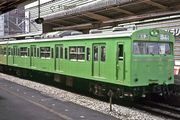
- 103 series (from December 1963 until June 26, 1988)[6]
- 205 series (from March 25, 1985 until April 17, 2005)
See also
- Osaka Loop Line
References
- ↑ JR East station ridership in 2008 Train Media (sourced from JR East) Retrieved February 12, 2010.
- ↑ MTA NYC Transit - Info
- ↑ Tube Prune LU Statistics Page
- ↑ "山手線6扉車を順次4扉車に (Yamanote Line 6-door cars to be gradually replaced with 4-door cars)" (in Japanese). Hobidas. Neko Publishing. 17 February 2010. http://rail.hobidas.com/news/info/article/113572.html. Retrieved 17 February 2010.
- ↑ "山手線、朝も全座席使えます 混雑率がちょっぴり改善". "Yamanote Line, seats available mornings too; crowding improved slightly." February 17, 2010. Accessed February 17, 2010. (Japanese)
- ↑ Japan Railfan Magazine, October 2008 issue, p.15
External links
- Stations of the Yamanote Line (JR East) (Japanese)
- japan-guide.com: JR Yamanote Line (English)
- Yamanote Line station information (unofficial, includes recordings of platform melodies) (English)
|
|||||||||||||||||||||||||||||
|
|||||||||||||||||||